The blog post introduces "Data Deep Dive," a new data analysis series, by examining its first data set: a detailed analysis of the severe storm that struck Lake Erie from August 29th to 30th, 2022, emphasizing the storm's impact and the significant insights gained from sensor data for applications in weather modeling, wildlife research, and community safety.
Listen to this article
Introducing the "Data Deep Dive" Series
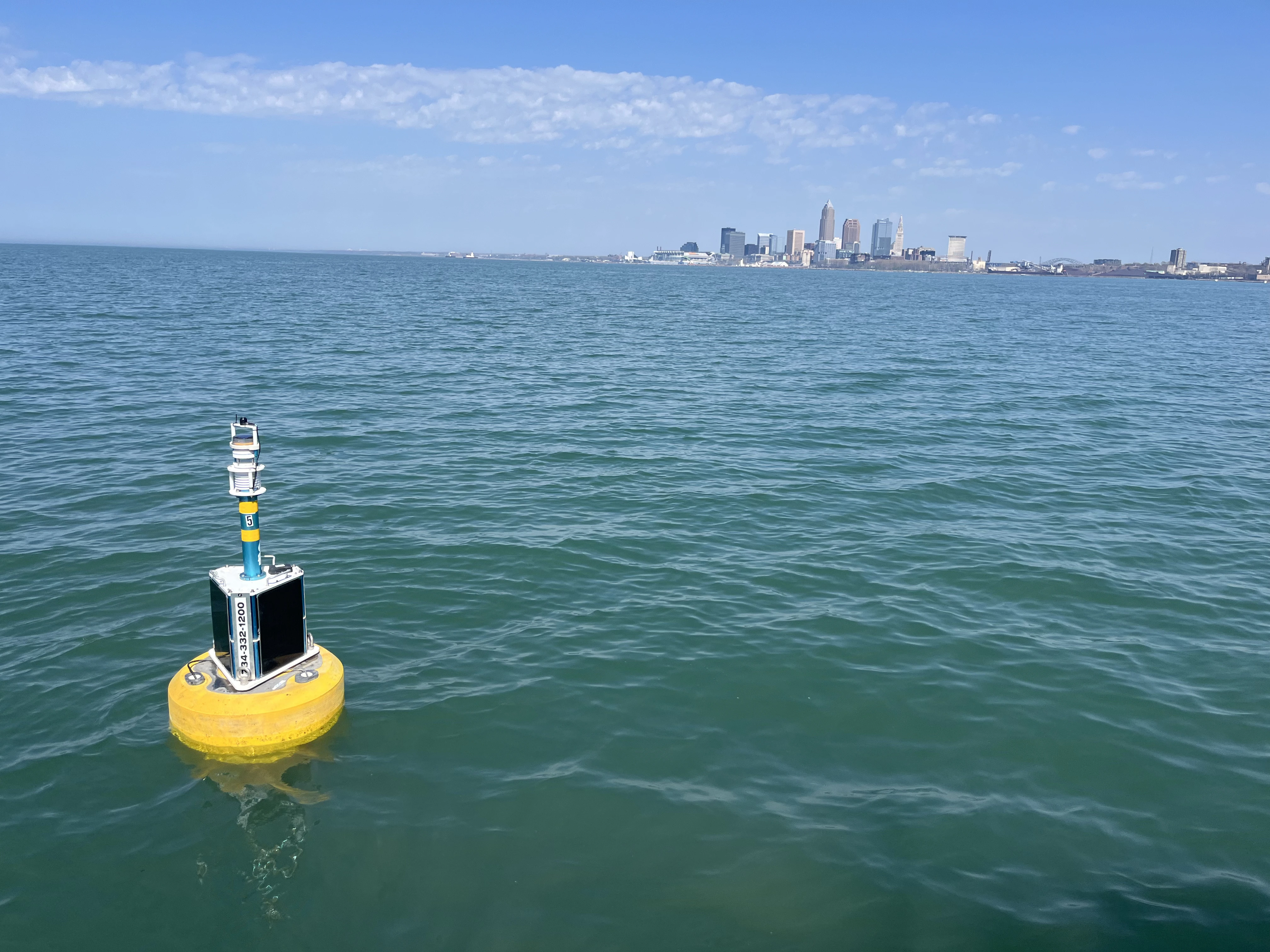
Cleveland Water Alliance has created the largest digitally connected freshwater body in the world: a telecommunications network of smart infrastructure to assist in the monitoring of the Lake Erie watershed. The Smart Lake Erie Watershed (SLEW) initiative provides information and insights from the deployed technologies spanning Ohio’s waterways. With two full-field seasons completed and nearly 20 million points of data collected from our smart sensors to date, CWA has a wealth of intelligence on our lake and other bodies of water that have not been available until now.
Smart Lake Erie Infrastructure and Uses
The SLEW infrastructure, a telecommunications network of over 200 sensors and 20 smart buoys, spans over 6,500 square miles of the Lake Erie watershed.
The Lake Erie smart sensors are increasingly informative and provide precise spatial data and temporal data monitoring and collecting real-time information about weather conditions, storm patterns, and other critical insights.
Sensors gather atmospheric data points, like rainfall, wave cycles, and wind speeds, seamlessly delivering real-time information used by our municipal, utility, and institutional partners.

From food production to manufacturing and shipping, access to water quality and marine weather data is essential to multiple industries and their operation capabilities. The commercial fishing industry is one such industry that relies on water quality and marine weather, adequate temperature, and conditions for farming, raising, and catching fish; recreational fishermen depend on the same conditions for leisure activities or providing food for their families.
Beyond commercial and recreational industries, other agencies, institutions, and individuals benefit from such information. The data Cleveland Water Alliance collects from our sensors provides critical information to manage and treat water. Municipalities and utilities like Cleveland Water, the 7th largest utility in the country, use data from our sensors as part of their water resource management to monitor water quality and residential, commercial, and industrial water use. As part of the management process, our municipal partners use CWA data to monitor water chemistry and environmental parameters, including oxygen levels. Substantial changes in oxygen levels are a serious concern, and monitoring our water systems for Hypoxia is vital.
Hypoxia refers to “water conditions where the concentration of oxygen is so low that it is detrimental to organisms, and very few organisms can survive in those conditions.”
Maintaining suitable oxygen levels is essential to keeping our water clean and safe, and with Lake Erie frequently experiencing hypoxic events, municipalities, and environmental groups need access to the critical information we provide. Such data assists with contaminant detection and predictive modeling that informs on varying treatment methods that water systems need when environmental changes occur, ensuring customers have continuous access to safe and clean drinking water.
Regardless of the applications and use of the data, understanding the health and conditions of our waterways is paramount.
Our new blog series, Data Deep Dive, seeks to delve into the exciting insights on the data captured by our sensors and the potential impacts such information provides.
Severe Storm Sweeps Across Lake Erie
We begin our series by diving into the severe storm events that struck Lake Erie at various intervals and intensities from August 29th to August 30th, 2022.
Beginning at 6 PM EST on August 29th, our sensors detected an intense storm passed over Lake Erie, traveling from West to East. Heavy rainfall and strong winds accompanied thunderstorms that spanned Northeast Ohio. Severe weather greatly impacted the lake, with winds and rain changing the lake’s condition from “Calm to Moderate” on the Douglas Sea Scale.

During the storm’s movement, harsh winds suddenly generated stronger waves along the lake, with some wind speeds reaching 20 miles per hour and waves in some locations seeing significantly increased wave height. Our SMART buoys noted varying conditions in different locations; for example, buoys near Port Clinton saw wave height increases of over 4 feet, while sensors near Ashtabula showed no significant changes. This data across Lake Erie has never been seen or contextualized in this way before. Information like this gives us new insight into the effect of storms across the lake.
Storms continued to move across the lake, with severe conditions finally calming at 6 AM EST on August 30th.
Wave Height (feet)


Wind Speed (miles per hour)


Lake Erie Sensor Data Applications
Cleveland Water Alliance data observed from the Lake Erie sensors presents valuable information for varying usages. The multi-point capability of our sensors captures a comprehensive picture, allowing us to see and understand storm and overall weather, water, and environmental data points while also tracking conditions that can impact the health and resilience of our waterways.
Obtained information from similar disturbances like the August 29th storm event can be used in several ways; four examples of practical applications include:
- Weather Modeling and Forecasting: Historical information on storm and environmental patterns assists with improving technologies and creating improved data models that allow for more accurate monitoring, tracking, and forecasting of atmospheric conditions and inclement events.
- Wildlife and Environmental Research and Conservation: Weather patterns and potential storms can help scientists and other researchers understand the lasting effects of flooding, hurricanes, tornadoes, and other severe weather events on our ecosystems. Such information provides needed insights for researchers working to preserve wildlife populations.
- Neighborhood and Community Safety: Forecasts are critical in ensuring community members are safe during severe weather events. In situations where protective measures (like preparedness planning, sheltering in place, and evacuations) need to be taken, having accurate information can save lives.
- Recreational Lake Usage: This kind of information can help boaters, fishermen, and other recreational lake users of Lake Erie understand how to safely interact with these kinds of weather events.

The Smart Lake Erie Initiative houses a network of infrastructure that delivers abundant information on numerous data points and valuable insights for individuals, organizations, businesses, agencies, and entities. The data collected from the August 29th weather event and the potential applications for such insights, including developing technological advances around weather modeling and predictions, providing real-time insights to keep community members safe during inclement storms, and helping wildlife research and conservation efforts, highlights the how important and invaluable data from Cleveland Water Alliance smart buoys are in monitoring, managing, and maintaining the Lake Erie Watershed and beyond.


.svg)


%20(1).webp)